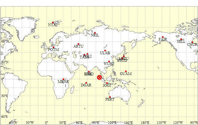
GPS Station Position Map and Epicenter (3.31N, 95.87E, 2004/12/26 0:58:53 UTC)
| GPSЌ‚ЋћЉФ•Є‰р”\ђё–§’P“Ж‘Є€К(HR-PPP)‚Й‚ж‚й’nђk”gЉП‘Є Seismic Wave Observation with GPS High-Rate Preceise Point Positioning |
200‚V/05/13 2006/05/10 |
Home |
GPSѓLѓlѓ}ѓeѓBѓbѓNPPP‚Й‚ж‚й’nЉk•П“®ЉП‘Є 5/13’З‰Б
GPS Kinematic-PPP (Precise point positioning)
: observation of crustal deformation by using
1-Hz GPS data
ѓZѓ~ѓiЋ‘—ї (2006/12) (ppt 6.4MB)
Ќ‚ЋћЉФ•Є‰р”\ђё–§’P“Ж‘Є€К(HR-PPP)‚Й‚ж‚й’nЉk•П“®ЉП‘Є
High-rate Precise Point Positioning: Detection
of crustal deformation by using 1-Hz GPS
data
Abstruct
Seismic surface waves caused by the Sumatra-Andaman
earthquake are detected by the GPS precise
point positioning (PPP) technique. The precision
of high-rate PPP is usually degraded by the
interpolation error of low-rate satellite
clocks. To solve this problem, 1-Hz satellite
clocks are estimated using the high-rate
observations at GPS stations worldwide. Subsequently
ground motions are analyzed by kinematic-PPP
using the 1-Hz satellite clocks. This technique
is referred to as high-rate PPP (HR-PPP).
By HR-PPP, the seismic waves generated by
the earthquake can be fairly detected. In
contrast to relative positioning conventionally
applied to GPS kinematic analysis, HR-PPP
can efficiently observe the widely distributed
crustal deformations generated by an earthquake
involving long-period waves. To validate
HR-PPP, the analyzed displacements are compared
with the seismograms. The HR-PPP solutions
are in very good agreements with the integrated
velocities measured using broadband seismometers
nearby the GPS stations.
.....................................................
T. Takasu, High-rate Precise Point Positioning: Detection of crustal deformation by using 1-Hz GPS data, GPS/GNSS symposium 2006, Tokyo, 2006, (PDF 594KB)
Ќ‚ЋћЉФ•Є‰р”\ђё–§’P“Ж‘Є€К(HR-PPP)‚Й‚ж‚йѓXѓ}ѓgѓ‰’nђk
’nђk”gЉП‘Є
Observation of seismic wave caused by Sumatra
- Andaman Islands earthquake with HR-PPP
Abstract
The seismic wave of Sumatra - Andaman Islands
earthquake (M9.0) is detected by GPS Precise
Point Positioning (PPP) technique (Zumberge
et al., 1997) with the high-rate GPS observation
data. The precision of the high-rate PPP
is usually degraded by the satellite clock
interpolation error of the precise ephemerides.
In this study, 2-step analysis procedure
is employed to solve the problem. Firstly,
high-rate satellite clocks are estimated
using world-wide IGS network high-rate observations,
with IGS precise satellite orbits and low-rate
clocks. Secondly, using the IGS orbits and
the 1-Hz clocks derived from the first step,
station coordinates are analyzed by the kinematic-PPP.
This strategy is called High-Rate PPP (HR-PPP).
The HR-PPP can fairly detect the displacements
caused by the seismic wave of the earthquake.
The relative positioning, generally used
for the GPS kinematic analysis, is difficult
to separate the movements of the rover and
the reference station and degrades the precision
with the long-baseline. The HR-PPP without
reference stations does not have such problems
and may be effective to analyze the crustal
deformation of the large scale earthquake
involving long period waves. To validate
the observed wave by the HR-PPP, the estimated
displacements are compared with the broad-band
seismographs located near the GPS stations.
In the high-frequency range above 0.01 Hz,
these are consistent. However, the differences
appear below 0.01 Hz. This might be caused
by low-frequency response function of the
seismograph. The long-period noise of the
HR-PPP, caused by the tropospheric correction
error and imperfect antenna phase center
models, is also the possible source of the
low-frequency differences and the future
research and development are necessary to
improve the technique.
Ќ‚ЋћЉФ•Є‰р”\GPSЉП‘Є‹ЗѓfЃ[ѓ^‚рЋg‚Б‚Дђё–§’P“Ж‘Є€К (PPP, Zumberge et al., 1997) ‚Й‚ж‚иѓXѓ}ѓgѓ‰-ѓAѓ“ѓ_ѓ}ѓ“’nђk (M9.0) ‚М’nђk”gЉП‘Є‚рЌs‚Б‚ЅЃBЌ‚ЋћЉФ•Є‰р”\PPP‚Й‚Ё‚ў‚Д‚Н’КЏнђё–§—п‚М‰qђЇЋћЊv•вЉФЊлЌ·‚Й‚ж‚йђё“x—т‰»‚Є–іЋ‹‚Е‚«‚И‚ўЃB–{Њ¤‹†‚Е‚Н‚±‚М–в‘и‚р–h‚®‚Ѕ‚ЯЃA‚ў‚Б‚Ѕ‚с‘SђўЉE‚М‘Ѕђ”GPS‹З‚МЌ‚ЋћЉФ•Є‰р”\ЉП‘ЄѓfЃ[ѓ^‚рЋg‚Б‚Д‰qђЇЋћЊv‚рђ„’и‚µЃAђ„’и‚µ‚Ѕ1-Hz ‰qђЇЋћЊv‚рЋg‚Б‚ДѓLѓlѓ}ѓeѓBѓbѓN-PPP‚Е‘Є€К‚рЌs‚¤2ѓXѓeѓbѓv‚М‰рђНЋи–@‚р—p‚ў‚Д‚ў‚йЃB‚±‚МЋи–@‚рЌ‚ЋћЉФ•Є‰р”\ђё–§’P“Ж‘Є€К (HR-PPP) ‚ЖЊД‚с‚Е‚ў‚йЃBHR-PPP‚Й‚ж‚й‰рђНЊ‹‰К‚Е‚НЉT‚Л—ЗЌD‚Й’nђk•\–К”g‚Й‚ж‚й‹З€К’u•П“®‚Є‘Ё‚¦‚й‚±‚Ж‚Є‚Е‚«‚ЅЃBђё–§‰рђН‚Й€к”К“I‚ЙЋg‚н‚к‚й‘Љ‘О‘Є€К‚Й‚ж‚йѓLѓlѓ}ѓeѓBѓbѓNGPS–@‚Е‚НЉођь—ј’[‹З‚М€К’u•П“®‚р•Є—Ј‚·‚й‚М‚ЄЌў“п‚Е‚©‚В’·Љођь‚Е‚Н‘Є€Кђё“x‚Є—т‰»‚·‚й–в‘и‚Є‚ ‚й‚ЄЃAЉоЏЂ‹З‚р•K—v‚Ж‚µ‚И‚ўHR-PPP‚Н‚±‚М–в‘и‚Є‚И‚ЃA“Б‚Й’nђk”gЊp‘±ЋћЉФ‚М’·‚ў‘е‹K–Н’nђk‚Й‚ж‚й’nЉk•П“®‚М‰рђНЋи–@‚Ж‚µ‚Д—L—Н‚Е‚ ‚й‚ЖЌl‚¦‚з‚к‚йЃBHR-PPP‚Й‚ж‚й‰рђНЊ‹‰К‚МЊџЏШ‚М‚Ѕ‚Я‹З€К’u•П“®ђ„’и’l‚рЉП‘Є‹З‹Я—Ч‚МЌL‘С€ж’nђkЊvЊv‘Є’l‚Ж”дЉr‚µ‚ЅЃBHR-PPP‰рђНЊ‹‰К‚Н0.01 Hz‚ж‚иЌ‚‚ўЋь”gђ”‘С€ж‚Е‚Н’nђkЊvЉП‘Є”gЊ`‚Ж—З‚€к’v‚µ‚Ѕ‚ЄЃA0.01 Hz€И‰є‚М’·ЋьЉъ‘С€ж‚Е‚Н€б‚ў‚Є–Ъ—§‚Б‚ЅЃB‚±‚к‚Н’·ЋьЉъ”g“®‚Й‘О‚·‚й’nђkЊv‰ћ“љ“Бђ«‚М–в‘и‚Й‹N€ц‚µ‚Д‚ў‚й‰В”\ђ«‚Є‚ ‚йЃB‚Ь‚Ѕ‘О—¬Њ—’x‰„•вђі‚вѓAѓ“ѓeѓi€К‘Љ“Бђ«ѓ‚ѓfѓ‹‚М•sЉ®‘S‚і‚Й‹N€ц‚·‚йHR-PPP‚М’·ЋьЉъѓmѓCѓY‚М‰e‹ї‚а‘е‚«‚ЃA‚і‚з‚Й‰рђНЋи–@‚М‰ь—З‚Є•K—v‚Е‚ ‚й‚ЖЌl‚¦‚з‚к‚йЃB
| Station ID | Location | Latitude (deg) | Longitude (deg) | Elevation (m) | Distance from Epicenter | Displacements by HR-PPP | Comparison with seismograph |
|---|---|---|---|---|---|---|---|
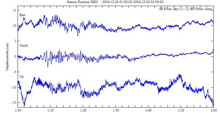
| JOGJ | Yogyakarta, Indonesia | 7.77S | 110.38E | 136 | 2024km | Fig | - |
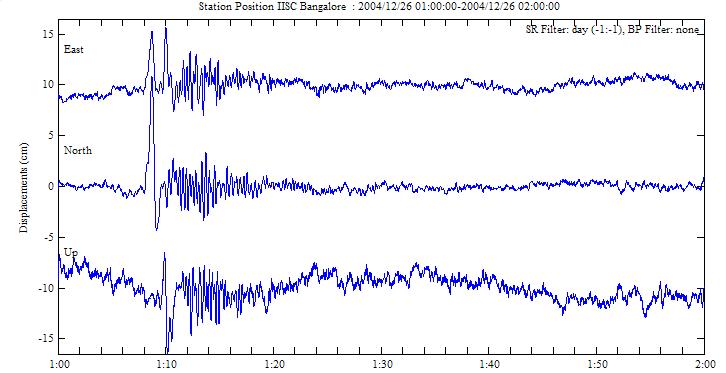
| IISC | Bangalore, India | 13.02N | 77.57E | 930 | 2283km | Fig | - |
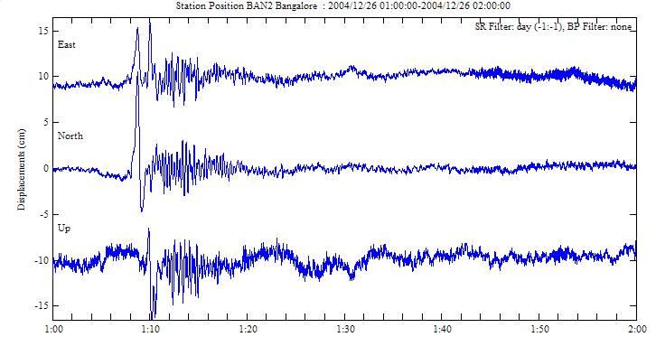
| BAN2 | Bangalore, India | 13.03N | 77.51E | 918 | 2289km | Fig | - |
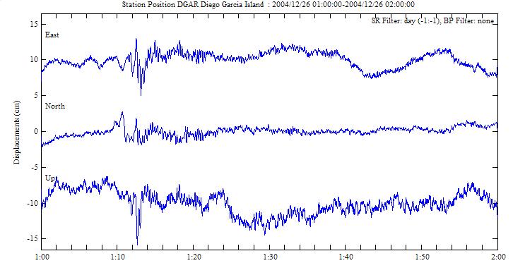
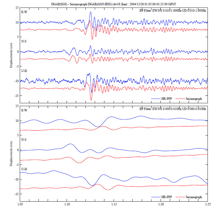
| DGAR | Diego Garcia Island, U.K | 7.27S | 72.37E | 10 | 2861km | Fig | Fig |
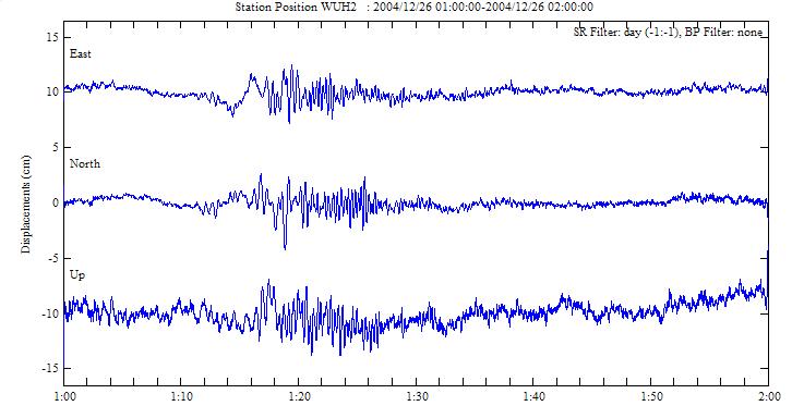
| WUH2 | Wuhan City, China | 30.53N | 114.36E | 43 | 3586km | Fig | - |
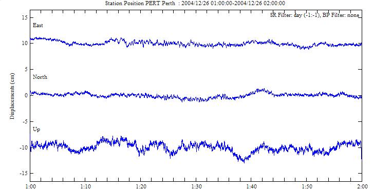
| PERT | Perth, Australia | 31.80S | 115.89E | 45 | 4425km | Fig | - |
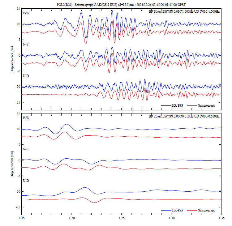
| POL2 | Bishkek, Kyrghyzstan | 42.68N | 74.69E | 1755 | 4841km | Fig | Fig |
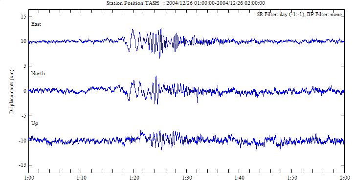
| TASH | Tashkent, Uzbekistan | 41.33N | 69.30E | 483 | 4979km | Fig | - |
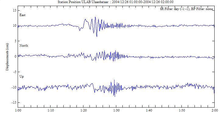
| ULAB | Ulaanbataar, Mongolia | 47.67N | 107.05E | 1649 | 5032km | Fig | - |
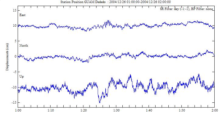
| GUAM | Dededo, Guam | 13.59N | 144.87E | 147 | 5503km | Fig | - |
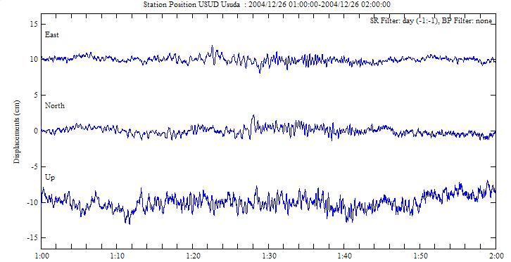
| USUD | Usuda, Japan | 36.13N | 138.36E | 1466 | 5672km | Fig | - |
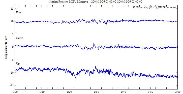
| MIZU | Mizusawa, Japan | 39.14N | 141.13E | 76 | 6048km | Fig | - |
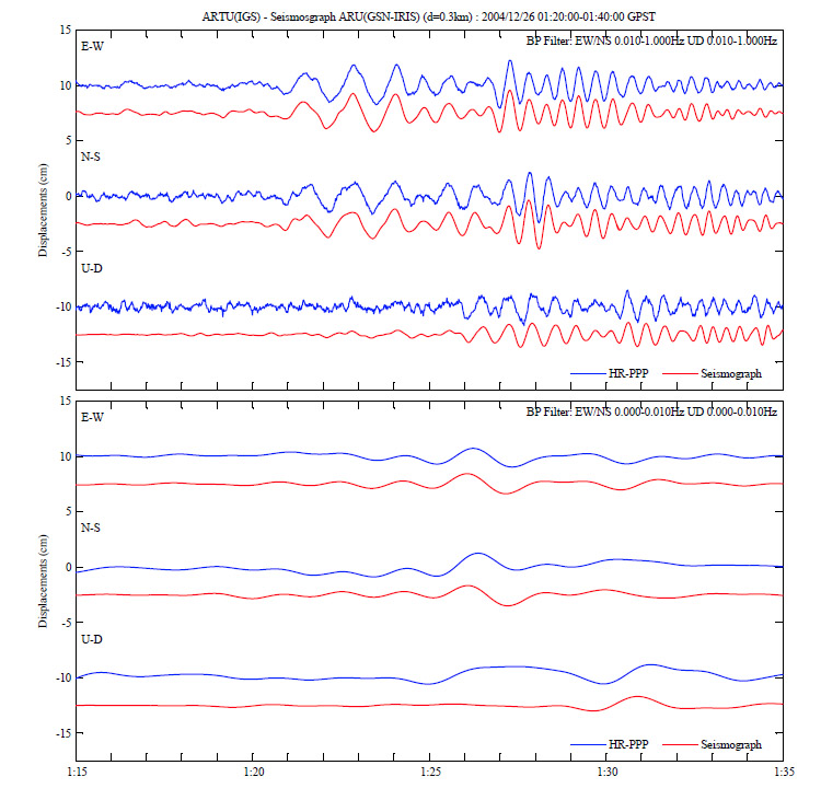
| ARTU | Arti, Russia | 56.43N | 58.56E | 254 | 6754km | Fig | Fig |
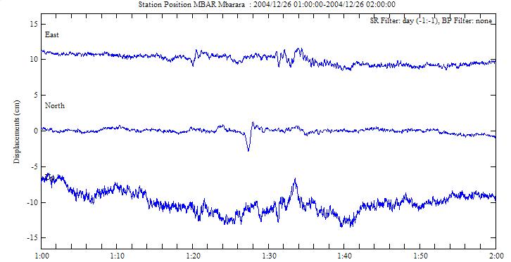
| MBAR | Mbarara, Uganda | 0.60N | 30.74E | 1349 | 7262km | Fig | - |
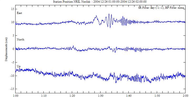
| NRIL | Norilsk, Russia | 69.36N | 88.36E | 62 | 7351km | Fig | - |
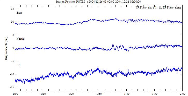
| POTM | Potsdam, Germany | 52.38N | 13.07E | 104 | 9230km | Fig | - |
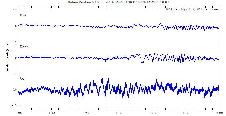
| NYA2 | Ny-Alesund, Norway | 78.93N | 11.86E | 45 | 9515km | Fig | - |
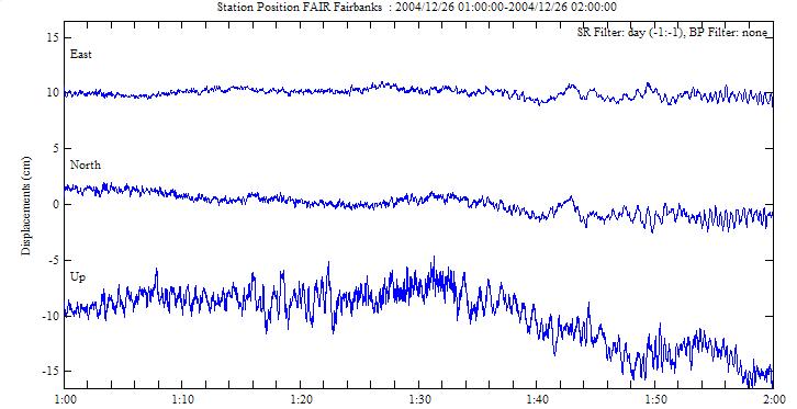
| FAIR | Fairbanks, USA | 64.98N | 147.50W | 308 | 10889km | Fig | - |
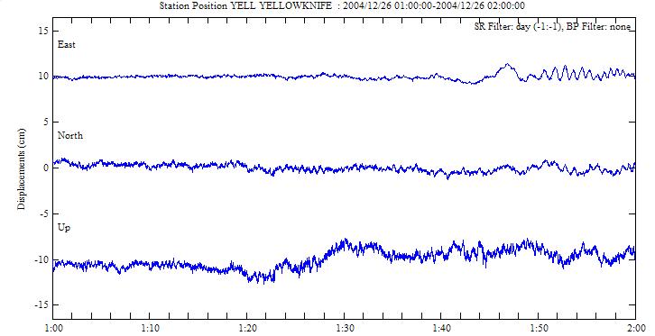
| YELL | Yellowknife, Canada | 62.48N | 114.48W | 208 | 12278km | Fig | - |
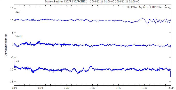
| CHUR | Churchill, Canada | 58.76N | 94.09W | 29 | 13076km | Fig | - |
GPS Station Position Map and Epicenter (3.31N,
95.87E, 2004/12/26 0:58:53 UTC)
ђ„’иЏрЊЏ
Estimation Parameters
ЃEAnalysis Software : GT0.6.2
ЃEEstimation Span : 2004/12/26 0:00-3:00GPST
ЃEEstimation Interval : 1sec
ЃEEstimation Pass : 3pass (Forward/Backward/Forward)+Smoothing
ЃEEstimation Strategy : PPP
ЃEReceiver Position Model : Kinematic
ЃEFixed Parametes : Orbit/ERP: IGS Final,
Clock: Estimated 1-Hz by GT (see below)
ЃEEstimated Parameters : Receiver Position,
Receiver Clock, Tropos ZTD/Gradients
ЃEMin Elevation : 10deg
ЃETropospheric Model : Saastamoinen
ЃETropospheric Mapping Function : GMF (Global
Mapping Function)
ЃETropospheric Gradient Model : Linear
ЃESite Displacements : Solid Earth Tide,
Ocean Loading(NAO.99b), Pole Tide
ЃESatellite/Receiver Antenna PCV : IGS_05.ATX
ЃEDetailed Processing Log : gpsestd.log
Satellite Clock : clk13030_00.clk.gz (5.3MB, Format : RINEX CLK)
ЃEEstimation Interval : 1sec
ЃEInput Parametes : Orbit/Clock/ERP: IGS Final
ЃEReference Clock : AMC2
ЃEIGS high-rate (1Hz or 0.1Hz) Station List
:
ALGO AMC2 AREQ ARTU BAN2 BOGT BREW CHUR DGAR
FAIR GLPS GODF GOLD GOPE GUAM HLFX HRAO IISC
ISPA KELY KOKB MAD2 MADR MALI MAS1 MATE MBAR
MIZU MKEA MSKU NNOR NRIL OKC2 OUS2 PERT PETS
PIMO POL2 POTM QUIN REDU SANT TASH TIDB ULAB
USN3 USUD VILL WUH2 YELL
HR-PPP‚Й‚ж‚й‹З€К’u•П“®ЉП‘Є
Station displacements observed by HR-PPP
(Time : GPST, Sidereal Filter: applied using day -1 (except for NYA2), Band-Pass Filter: None)
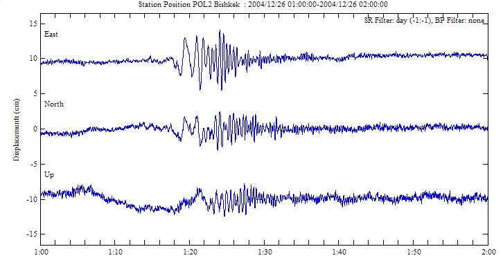
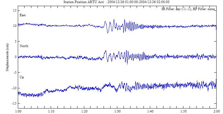
ЌL‘С€ж’nђkЊv‚Ж‚М”дЉr (upper : 0.01Hz- , lower
: 0-0.01Hz)
Comparison with broad-band seismographs
| Home |